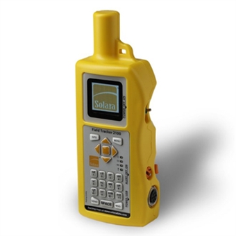
Field Tracker 2100
The Solara Field Tracker 2100 is designed, tested, and built by Solara for easy portable use in the toughest, most extreme environments. It is 25% lighter than the Field Tracker 2000 that also includes a tactile-response keypad, for situations where the user would like a lighter unit to carry as they travel. Using the Iridium Low-earth Orbit satellite system, the Field Tracker 2100 transmits and receives messages in less than a minute anwhere on earth with a clear view of the sky.
- Real-time GPS tracking protects and optimizes your most valuable assets by:
- protecting personnel in the field through instantaneous knowledge of their location, no matter how remote;
- lowering your fleet fuel expenses, insurance costs and lost labour time; and
- locating stolen assets anywhere in the world.
- Operation is simple and automated with:
- automated transmission of unit position at user-settable intervals;
- two-way text message communication using the Iridium satellite system, ensuring every message is successfully sent;
- internal rechargeable battery, with several charge uptions including solar charging with the provided solar panel;
- an ability to send an alert notification signal to anyone monitoring the Field Tracker 2100;
- Alerts can be routed to your organization's command centres or monitored through an optional add-on service. Two-way communication ensures you can tell the person monitoring what the alert is for;
- manual and quick-start sheet to get you up and running quickly;
- optional cold-weather battery kit for extreme cold operation;
- simple configuration of the Field Tracker 2100 using on-screen menus;
- easy user configuration of optional settings through the secure Solara User Web site; and
- system access options through Solara to suit your needs.


 To the top