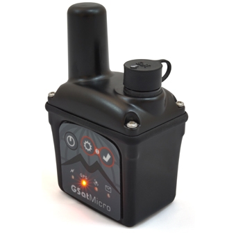
GSatMicro
The GSatMicro is a powerful, small, customizable, self-contained Iridium tracker. It transmits positions, SOS alerts and other specialized information through its industry-leading satellite antenna and electronics technology to be monitored and analyzed in real time. Configuration capabilities enable the support of any asset and type of information, allowing the GSatMicro to be used in many different applications.
The GSatMicro is a tracking solution that is extremely small yet very versatile. It is a fully scriptable device with eLua so any average user, or our own engineers, can rapidly design scripts to support any user application. Interconnecting the device with other hardware, user input interfaces, monitoring hardware, or environment data becomes very simple. Charging is supported over USB or regular DC voltage for versatility, includes a serial port for programming and control, SiRF V GPS with Galileo + GLONASS support, Bluetooth 4.0, two inputs, two outputs, accelerometer, and digital compass.
Small & Lightweight
The GSatMicro is the smallest self-contained Iridium tracker in the world! It can transmit your location from anywhere in the world and is built on the latest satellite, antenna, and electronics technology to track, monitor and analyze in real time!
Truly Global Operation
By utilizing the Iridium network, the GSatMicro can track an asset anywhere on earth using the most advanced low earth orbiting satellite network in existence.
Versatile
The GSatMicro can be used in maritime, aircraft, personnel, and vehicles, and is ideal for applications such as: security and safety, fleet management, oil and drilling, soldier tracking, and secure government applications.
- 32-bit Cortex ARM processor with a fully user customizable LUA Scripting Language
- Bluetooth 4.0 (BLE)
- AES 256-bit Encryption
- SiRFstarIV GPS with an amazing -163dBm sensitivity
- Internal 2.5Ah Lithium Polymer battery & charger
- Battery Fuel Gauge
- Integrated high gain ceramic antenna dual tuned for Iridium and GPS
- Over the air configuration of the terminal
- SOS Button
- Accelerometer
- Magnetic Compass
- Weather Resistant Case
- Truely global coverage with the Iridium Satellite Network


 To the top