
Wireless Interfaces
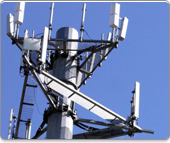
GSM
GSM coverage provides optimal tracking coverage for those located in populated, urban areas. Tall buildings, concrete, and steel all act as a deterrent for satellite signal. Cellular signal provides the best solution for asset tracking when operations occur in developed areas. Tracking via your Blackberry or iPhone device has never been so simple since Vessel Mapping integrated them onto its system.
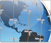
Satellite
From the Arctic to the Antarctic, and everywhere in between, satellite coverage provides a truly global network for tracking assets anywhere in the world. Removing any notion of the unknowing allows business owners and managers to make informed decisions to better monitor and control their assets. Knowing where your assets are at anytime provides peace of mind and security, along with increasing operations, thanks to a diverse network of satellite coverage.

 To the top